File:Gps-multipath-efect.png
From Vigyanwiki

No higher resolution available.
Gps-multipath-efect.png (600 × 386 pixels, file size: 513 KB, MIME type: image/png)
| Description |
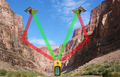
English: Multipath efect in GPS signal. Green color indicates the direct path of the waves, the red color indicates reflected waves.
Español: Efecto multitrayecto de la señal GPS. El color verde indica el trayecto directo de las ondas, el rojo las ondas reflejadas. |
| Date | |
| Source |
|
| Author | derivative work: Javiersanp |
| Other versions |
|
| This is a retouched picture, which means that it has been digitally altered from its original version. Modifications: Collage. The original can be viewed here: Canyon midday.jpg:
|
This file is licensed under the Creative Commons Attribution-Share Alike 3.0 Unported licence.
- You are free:
- to share – to copy, distribute and transmit the work
- to remix – to adapt the work
- Under the following conditions:
- attribution – You must give appropriate credit, provide a link to the licence, and indicate if changes were made. You may do so in any reasonable manner, but not in any way that suggests the licensor endorses you or your use.
- share alike – If you remix, transform, or build upon the material, you must distribute your contributions under the same or compatible licence as the original.
Original upload log
This image is a derivative work of the following images:
- File:GPS tracking satellites.jpg licensed with Cc-by-sa-2.5,2.0,1.0, Cc-by-sa-3.0-migrated, GFDL
- 2007-04-21T06:19:59Z Theonlysilentbob 1536x2048 (385521 Bytes) == Summary == {{Information |Description = Garmin eTrex Yellow GPS acquiring satellite signal |Source = Not Applicable |Date = April 21st 2007 |Author = Vaughan Weather |Permission = Anyone can use and freely distribute this
- File:Navstar-2.jpg licensed with PD-USGov-Military-Air Force
- 2005-03-26T18:06:36Z GDK 400x400 (20897 Bytes) NAVSTAR-2 (GPS-2) satellite Source: http://www.jpl.nasa.gov/images/grace/grace_083002_browse.jpg Status: PD-USGov-Military-Air Force {{PD-USGov-Military-Air Force}} [[Category:Satellites]]
- File:Canyon midday.jpg licensed with Cc-by-sa-3.0-migrated, GFDL
- 2008-04-29T11:50:09Z Movieevery 2272x1566 (1693780 Bytes) cropped
- 2008-01-03T19:54:12Z Gridge 2272x1704 (1279497 Bytes) {{Information |Description=A picture of the Marble Canyon section of the Grand Canyon, from river-level. |Source=Originally from [http://en.wikipedia.org en.wikipedia]; description page is/was [http://en.wikipedia.org/wiki/Im
Uploaded with derivativeFX
File history
Click on a date/time to view the file as it appeared at that time.
| Date/Time | Thumbnail | Dimensions | User | Comment | |
|---|---|---|---|---|---|
| current | 19:20, 9 April 2010 | | 600 × 386 (513 KB) | wikimediacommons>Javiersanp | {{Information |Description={{en|1=Multipath efect in GPS signal. Green color indicates the direct path of the waves, the red color indicates reflected waves.}} {{es|1=Efecto multitrayecto de la señal GPS. El color verde indica el trayecto directo de las |
File usage
The following page uses this file: